


Saturns Breath (highlights)
Highlights of video. With thanks to Lima-based, Independent Arts Organisation, HAWAPI, for supporting & enabling this research.
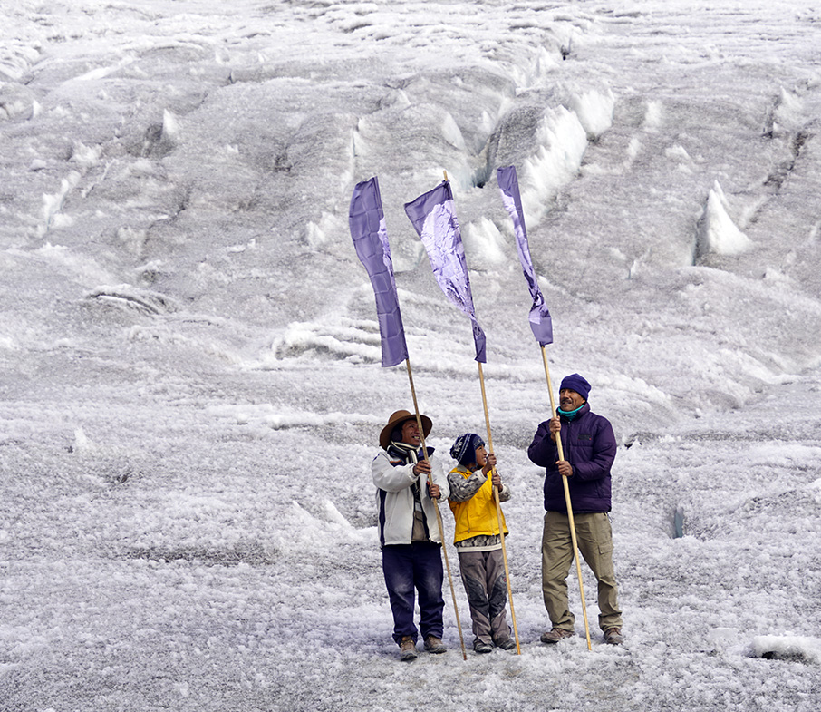
Flags bearing an image of an oversized galena crystal (lead/silver/zinc) representing the galena mined at Potosí, were raised over the Quelccaya ice cap by men from the region, in an act of recognition of the molecular level territorialisation. These flags also act as standards to identify the emergent anthropogenic landscape- lead over ice, extraction over precipitation.
In 2021 these galena flags, along with water collected from the Quelccaya glacier, will be taken to Potosí to complete the line of enquiry.
Saturn’s Breath is a part of a multistranded line of enquiry, Think Like a Mountain, centred on Quelccaya Icecap, in the Peruvian Andes.
The wider project is about circulation, across a series of meanings. The line of inquiry maps at a molecular level the movement of lead resulting from silver mining, from the largest Spanish colonial silver mine Potosí (Bolivia).
Lead dust, windborn across Quelccaya ice over the centuries, has generated a time capsule of environmental contamination, and Quelccayan ice core samples trace in a vertical ice column the economic and extractive output from the mine, and map the rise and fall of the Spanish empire.
For more background into the science click: HERE
Taking as a starting point the first official Australian colonial currency: Macquarie’s holey dollar.
In the face of insufficient British currency in the colony, in 1812 Govenor Lachlan Macquarie ordered a consignment of £10,000 worth of Spanish silver dollars, the most widely traded currency at the time.
The silver in the coins was mined from Spanish colonial mines in Peru and Mexico, which were heavily worked across two centuries under punishing human and environmental conditions. Some of this silver came from the largest Spanish colonial mine of the time, Potosi silver mine in Peru (now Bolivia). Lead released from mining silver at Potosi in the 17th and 18th century has been detected, wind-born, in ice core samples from the Quelccaya ice cap, the largest tropical ice-mass in the world.
Lead dust, falling with snow, was compressed across the years and centuries. Ice cores extracted from the glacial ice, compressed frozen water and atmospheric impurities, are a vertical time capsule and map of human activities, able to trace through mineral contamination in layers of ice, the activities of the Spanish colonial empire.
Quelccaya ice cap, in the Peruvian Andes, is the largest tropical ice mass in the world, sits at 4000 m elevation, and has been the focus of decades of international climate research, as a mid-point between the poles. Ice cores from Quelccaya have been used to understand more about the climate across the last 10,000 years.
Quelccaya, like all glaciers, is melting, and modeling indicates that it will be gone within 50 years. Upcoming work will model this regression, from 2000-2070.
Walking the Ice Library (shorts) 2020
Collapsing the space between two anthropogenic landscapes, a10000 year old glacial valley at the foot of Quelccaya and an icecore storage facility, Copenhagen
Time spent at the Centre for Ice, Climate and Earth at the Niels Bohr Institute, Copenhagen.
This freezer room holds 60 years of ice core samples from the NBI projects, collecting ice back to the last ice-age, 40,000 years old, drilled up to 1400 m down into the Greenland icesheet.
The boxes contain ice cores sufficient to stretch for 10 km if laid end to end. Analysis of this ice is revealing ongoing data about past environmental conditions: ancient air and atmospheres captured in falling snow.
New work 2021: Sound of wind through the crystalline forest
commissioned for CRISTAIS DO TEMPO/ TIME CRYSTALS, curated by Alexandre Milagres, MMGerdau Museum of Mines and Metal, Brazil.
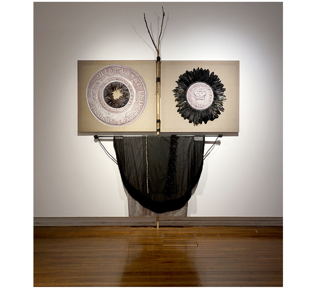
Prepositionally past-casting a view of the site of Potosí silver mine (the largest silver mine in history), on the Cerro Rico mountain, Bolivia, as it may have appeared just before silver was discovered in the 1500s.
Amongst some now-rare queñua trees is a grouping of flags depicting a galena crystal, the silver mineral load that was mined at Potosí. The mountain dreams of its future.
With thanks to Dr Paul Vallelonga, Dr Thomas Blunier and the team at the NBI. Dr Vallelonga’s work on measuring lead impurities in icecores, and particularly in analysis of data from Quelccaya was invaluable to this research. More information: HERE
Performative walk with Luis Maria, landowner, 1797 margin
Quelccaya 1997, modelled by Dr Christian Yarleque, National Institude for Research on Glaciers, Peru
Latitude and longitude markers for 1797 and 1997 margins
The THINK LIKE A MOUNTAIN project aims to map the western margin of the Quelccaya ice cap, where it would have extended to in 1797 and in 1997; from the approximate beginning of the industrial revolution and 200 years later when the Kyoto protocol was signed. This line, between rock and ice, considers the effect of climate change on this landscape, across this 200-year window of attitudes, colonisations, and economic thinking in relation to the environment.
A work in progress video will map this line through a combination or walking, drone flight and virtual 3D space. Scientific advice, data and assistance has been provided by Dr Christian Yarleque, National Institude for Research on Glaciers, Peru and Dr Douglas Hardy, University of Massachusetts.
‘Thinking like a mountain’ was coined by mid-century American ecologist, Aldo Leopold, to describe the interconnectivity of the environment and its ecosystems. A Sand County Almanac. 1949.
Link to catalogue essay from DUMP, by Anneke Jaspers, considering ideas around circulation: HERE